
As if 2020 didn’t have enough going for it already, forecasters expect an especially busy hurricane season this year.
“It’s one of the most active predicted since 2005, which was a very active year,” said Monica Allen, a spokeswoman with the National Oceanic and Atmospheric Administration (NOAA). “We’re predicting 25 named storms for this year. That’s more than we’ve ever predicted.”
For those with short memories, 2005 shattered records, with 31 tropical or subtropical cyclones recorded. Ultimately, there were 27 named storms that year, exhausting the letters of the alphabet. Of those, 15 reached the level of a hurricane, with four of those reaching Category 5, the highest ranking on the existing scale.
Most remember Hurricane Katrina, which devastated the Gulf Coast and dealt a catastrophic blow to New Orleans, but the strongest storm of that year was Wilma, which barreled along, in October, taking a deadly and costly toll, in Mexico, Florida, and elsewhere.
That was the most intense cyclone of the western hemisphere on record up until Hurricane Patricia intensified off Mexico’s Pacific Coast, in 2015, the most intense tropical cyclone on record in terms of wind speed, reaching the Category 5 top of the scale in record time, with maximum sustained wind speeds recorded at an extraordinary 215 mph.
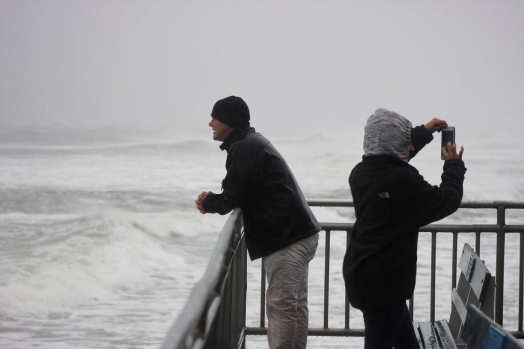
So far, this season has not seen anything so intense, although Tropical Storm Isaias struck Cape May County hard. Intense winds battered the area, with the most dramatic damage from a tornado that tore through Marmora.
Later, Tropical Storm Kyle passed the coast far out to sea, while Tropical Storm Josephine dissipated Aug. 16. Late last week, forecasters were keeping an eye on Tropical Storm Laura, with fears it could strengthen into a hurricane, with yet another storm forming behind it, named Marco.
“This year, we expect more, stronger, and longer-lived storms than average…”
Gerry Bell, Lead Seasonal Hurricane Forecaster, NOAA’s Climate Prediction Center
In August, the National Weather Service updated its 2020 prediction, stating that this year is already in line to be one of the busiest storm seasons on record. Officials called for caution and preparation as the season continues.
“We encourage all Americans to do their part by getting prepared, remaining vigilant, and being ready to take action when necessary,” stated U.S. Secretary of Commerce Wilbur Ross.
Hurricane season continues until Nov. 30.
Warming Seas Equals Stronger Storms
While officials worry about the dangers of hurricanes this year, Hiroyuki Murakami is looking at the longer term. A climate researcher at NOAA’s Geophysical Fluid Dynamic Laboratory, in Princeton, Murakami was the lead author of the research published this year connecting human-caused climate change to where tropical storms occur.
According to his research, the future may hold fewer tropical storms for much of the world, but the storms that are seen are likely to be more powerful, and likely more destructive because of it.
For more than a decade, in Japan, and in the U.S., Murakami studied the impact of climate on storms.

While much of the discussion on the potential impact of a warming planet centers on air and surface temperatures around the world, the oceans are warming, too. That means changes to ocean currents, and more water in the seas as the ice-covered poles melt. Warmer water also expands, further increasing instances of coastal flooding.
A 2016 report from the federal Environmental Protection Agency found that New Jersey is especially vulnerable to rising seas, even compared to other coastal communities, because the land is simultaneously sinking. It may also face more intense storms if the trend continues.
“Many climate models suggest that as the sea surface ocean temperatures become much higher, it may lead to more intense storms everywhere in the world,” said Murakami. “We may see more intense storms in the future due to global warming.”
Some studies indicated hurricanes have already become stronger in this century.
“It’s clear that we’ve seen more intense storms at the regional scale, especially on the East Coast of the U.S.,” he said.
So far, he is not able to say any particular storm was bigger, stronger, or faster because of climate change driven by human beings. For instance, while Hurricane Sandy’s wind speeds fell below those of a Category 1 hurricane just as it made landfall, in New Jersey, hitting Brigantine with winds of 80 mph, the storm was extraordinarily massive, ranging over 1,000 miles, stretching from Virginia to New England.
In New Jersey, the storm totaled billions of dollars’ worth of damage and cost several lives.
According to Murakami, a storm of that sort is too unusual to have enough data to say with any certainty what effect climate change may have had in its formation or impact.
“It’s really difficult to say something for individual storms, not only Sandy but for other storms, whether this specific event is due to global warming or not,” he said, in a recent interview, “but statistically, we will see more large storms in the future.”
Complicated Science
Records show water temperatures around New Jersey have been increasing, but, according to Murakami, the warmth of the water in the tropics, where storms are born, is likely to have a greater impact on the size and strength of storms.
“If you see warm ocean temperatures, it means a very active hurricane season,” he said.
Other factors have an impact. For instance, fine particles of solids or gas in the atmosphere, referred to as aerosols, can reflect sunlight and reduce warming. They get into the air from burning fuel and other human activity, and naturally, through volcanos, blowing dust, and many other ways.
“We may see more intense storms in the future due to global warming. It’s clear that we’ve seen more intense storms at the regional scale, especially on the East Coast of the U.S.”
Hiroyuki Murakami, Climate Researcher, NOAA’s Geophysical Fluid Dynamic Laboratory
According to Murakami’s research, perhaps counterintuitively, the reduction of manmade aerosols in the atmosphere, as humans work to reduce air pollution, is one reason storms have strengthened over the past 40 years.
This year, massive dust clouds kicked up in the deserts of Northern Africa may have helped reduce the warmth around the nascent storms, and may have kept any of the record-breaking numbers of storms from becoming a full-blown hurricane so far this year.
Allen warned that effect is likely to fade into September and October, suggesting no one can assume they are in for an easy time this year.
La Ñina and El Ñino also have an impact. For 2020, the possibility of La Ñina developing may reduce surface water temperatures in the eastern Pacific, which may weaken the wind shear over the Atlantic Basin, allowing storms to develop and intensify, according to information from NOAA.
“This year, we expect more, stronger, and longer-lived storms than average, and our predicted ACE (Accumulated Cyclone Energy index, which measures the combined intensity and duration of all named storms during the season) range extends well above NOAA’s threshold for an extremely active season,” said Gerry Bell, the lead seasonal hurricane forecaster at NOAA’s Climate Prediction Center, in a prepared statement.
Warm Water Charges Storms
At the most basic level, the physics of tropical storms seems straightforward. Warm air rises. The wide stretches of moist, warm air, in the tropics, cause a great deal of air to rise. As that air cools, it is pushed aside by more rising air warmed above the tropical water.
This rising air generates massive amounts of energy. The curve of the earth’s surface means the path of the air and the water currents also curve – what’s called the Coriolis effect – which, in the northern hemisphere, spins the storm counterclockwise around the low-pressure eye.
In the South Pacific and Indian Ocean, these storms are called cyclones, and typhoons over the northwest Pacific Ocean. In the North Atlantic and Northeast Pacific, the storms that grow strong enough are called hurricanes.
According to a synopsis of Murakami’s extensive research, greenhouse gasses warming the upper atmosphere creates a more stable condition, which means there is less chance the rising currents of warm air will form into tropical depressions and then into tropical storms.
“It’s really straightforward to me because we know greenhouse gases will increase the intensity of tropical cyclones. If we want to decrease intense storms, it’s easy. We try to reduce greenhouse gas emissions.”
Hiroyuki Murakami, Climate Researcher, NOAA’s Geophysical Fluid Dynamic Laboratory
The long-term models indicate fewer tropical cyclones will form toward the end of the 21st century, according to information released by NOAA. This is expected to affect the entire planet, except for the Central Pacific, including Hawaii. That region could see an increase in the total number of storms. The East Coast is projected to see fewer storms by the end of this century.
Those that do form will likely pack more of a punch because of the increased energy of the significantly warmer tropical waters expected in the future. According to Murakami, that could mean a hurricane that would have once reached Category 1 could instead make landfall as a Category 2 or 3.
Less clear is the effect of a warmer planet on other storms, blizzards, or the northeast storms that have proven damaging to the New Jersey coast. In a recent interview, Allen said she was not familiar with studies of that, but Murakami said he saw some work from colleagues indicating winter storms, too, could be worse in the future, but he added that is not his area of expertise.
A Straightforward Answer
In a statement released by NOAA, outlining Murakami’s studies, he said his team hopes the research helps decision-makers better understand the forces driving storm patterns and make plans to protect lives and infrastructure.
In an interview, his primary policy suggestion was to reduce carbon emissions worldwide.
“It’s really straightforward to me because we know greenhouse gases will increase the intensity of tropical cyclones. If we want to decrease intense storms, it’s easy. We try to reduce greenhouse gas emissions,” he said.
He also acknowledged the solution may be more complicated, as both policymakers and the public seek ways to drive economic development, especially as the pandemic cripples whole sections of the economy.
“That is a very challenging issue,” he said.
This story was produced in collaboration with CivicStory and the New Jersey Sustainability Reporting Hub project. It was originally reported by Bill Barlow for the Cape May County Herald, and may be re-distributed through the Creative Commons License, with attribution.

